|
B&B chambres & tables
d'hôtes Cevennen & Mont Lozčre
cevennes-mont-lozere.com
|
|
B&B chambres & tables
d'hôtes Cevennen & Mont Lozčre
cevennes-mont-lozere.com
|
|
|
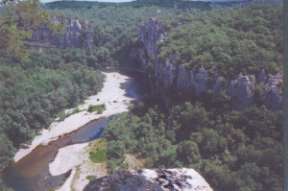 |
The rock faces are ideal for canyoning
but also for adventurous hikes along and through the riverbed. Of interest for the
speleologist is the large variety of caves in the soft limestone rock. The Cevennes (spread over the Gard and the Lozčre ) are characterised by shale and the mont Lozčre by granite. The Aubrac is formed by high basalt plateaus and non-active volcano's. |
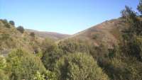
The Aubrac and the Margeride have an average altitude between 1100 and 1200 meters, with a middle mountain climate. Same goes for the Mont Lozčre , of almost 1700 meters from which the department owes its name. It is the highest mountain of the Languedoc-Roussillon region. In winter you can practise winter sports, such as : alpine and Nordic ski, hikes with snowshoes or make a sleigh ride with huskies... |
|
    |
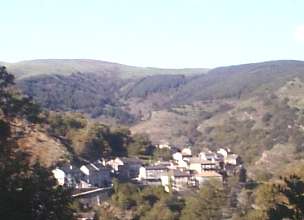
The
Cevennes have an altitude of between 300 and 900 meters, like the "Gorges du
Tarn" and the "Gorges de la Jonte", with a Mediterranean
climate.
|
| Bed & breakfast and dinner & apartment cevennes-mont-lozere.com 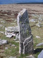
|
||
| Patricia
Tholet Au Porteau Valcrouzčs 48800 Saint-André Capcčze France Tel/fax 00 33 4 66 46 20 10 e-mail : au-portaou@wanadoo.fr www.au-portaou.com |
Dominique & Noël La Combette 48190 St. Jean du Bleymard France Tel :00 33(0)4 66 48 61 35 e-mail:lacombette@wanadoo.fr www.lacombette.com
|
|
 Activities, roads, sites & links |
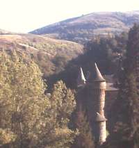
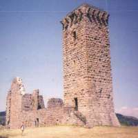
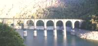
| Ancient roman roads Allenc Alčs Old farmhouses Anduze Architecture Aubaret fortified farm Aujac Badaroux Bagnols les-bains Biological agriculture La Bambouseraie, bamboo gardens Bateliers de la Malčne Bellecoste Belvédčre de Bouzčdes Belvédčre du Chassezac Belvédčre de Truel Le Bleymard Les Bondons Canyoning Cartes IGN: 1/25000 www.ign.fr 1/100 000 n° 50 et 59 Cčze Chestnuts Railway Clermont Ferrand-Genolhac-Alčs Castles : Le château d'Aujac Le château de Tournel Le château de Portes Le château de Brésis Le château de Luc Snow storm warning bell-tower Clochers de tourmente (Auriac, la Fage, Sagnes, Servičs) Chareylasses Honey factory Le col de Finiels Concoules Cubičres Cures thermales Cyclotourism D 104 D 901 D 998 D 906 |
Ecomuseums Cevennes National park : Les
écomusées du parc national des Cévennes L'Ecomusée du Mont Lozčre Ecomusée des Cévennes Ecomusée de Causse et gorges Romanesque churches Church of Bonnevaux The Roure farm Farm and breadoven of Troubat la Fage (Le ferradou de) Fishing Florac Flora and fauna Grotto of Dargilan Aven-armand La Garde - Guérin Gastronomie Gorges du Tarn Gorges du Chassezac Gourmandise GR 7 and 7 A GR 44 GR 68 GR 72 Caves (Aven Armand, Dargilan e.a.) History Largentičre Lanuejols and Mausoleum Luech Mas Camargues (pnC) Malon et Elze Markets Marvejols Mielerie Le Mont Lozčre Menhirs de Bondon Mountainbiking Cevennes national park OTSI Villefort OTSI Genolhac Przwalski horses Troutfishing Pic de Loup |
Langogne Le lac de Villefort Le Pont de Montvert Le Pont de Sénechas Le Pont double de St. André de Capcčze Le parc des bisons d'Europe Le parc des Loups du Gévaudan Mende Musée Pierre André Benoit (Alčs) Musée municipal du Colombier (Alčs) Musée mine témoin (Alčs) Musée vivant de la laine (Langogne) Musée "de la terre ŕ l'acier" (St. Chély d'Apcher) Pęche Pont du Tarn Pont de Rastel Poteries d'Anduze Randonnée pédestre et équestre Randonnées Mont Lozčre La Régordane Remise en forme RN 106 + RD 106 Route des Crętes (D 35) Le chemin de Stevenson Saint Ambroix St. Chély d'Apcher Ste Enimie Sénechas Source du Tarn Ski alpin et ski nordique Les stations de ski : Le Bleymard : 1400-1702m 7 pistes ski alpin et 5 pistes de ski de fond - Mas de la Barque 1340-1650m. 5 pistes de ski de fond. Stages patchwork Topoguide GR70 réf 700 Chamina.comm Tour du Mont Lozčre Vallon de Villaret Viaduc de Chamborigaud Vialas Vielvic Villefort VTT - Traversée Massif Central Vultures |
La Combette in St. Jean du Bleymard, at the foot of the mont Lozčre and Au Portaou in the in the Cévennes between Villefort and Genolhac Combined stay : If you would like to get to know the various aspects of the region, you can reserve the Cevennes-Mont Lozčre formula : for example 4 days at La Combette and 4 days at Au Portaou in either order, transport of luggage on request. 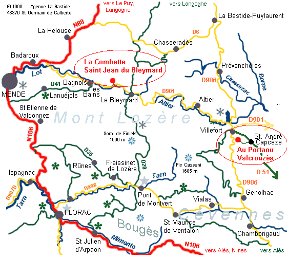 Region Cevennes, Mont Lozčre - bordering the Cevennes national park in the South of France. map parc national des Cévennes |
|
B&B chambres & tables
d'hôtes Cevennen & Mont Lozčre
cevennes-mont-lozere.com
|
![]()
© 2002 - 2016 www.cevennes-mont-lozere.com | mentions légales | Présent sur Causses Cévennes
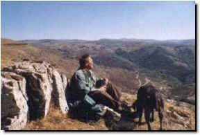
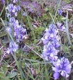 Lovers of nature, flora and fauna
will be spoiled here. The flora of the Lozčre is remarkable, from April till the end of
autumn there is a successive flowering of: broom, wild narcissus,
Lovers of nature, flora and fauna
will be spoiled here. The flora of the Lozčre is remarkable, from April till the end of
autumn there is a successive flowering of: broom, wild narcissus,